Voyafield · Articles · 2026-08-21 · English
Thinking about Nagasaki from the Sea—Why It Does Not Fit into a Single Itinerary
Part 1 of a five-part series
Introduction
Many readers outside Japan would probably not be able to point to Nagasaki on a map as soon as they hear its name, or say how far it is from Tokyo and how to get there. Even within the prefecture, “Nagasaki” is not only a city on the mainland. Nagasaki Prefecture has an especially large number of islands, and those islands too are part of “Nagasaki.”
1. Nagasaki is in southwestern Japan
Japan consists of 47 prefectures. They are often described as parts of broader regions such as Kanto, Kansai, and Kyushu. Tokyo is in Kanto in eastern Japan, while Nagasaki Prefecture belongs to Kyushu in the southwest of the Japanese archipelago.
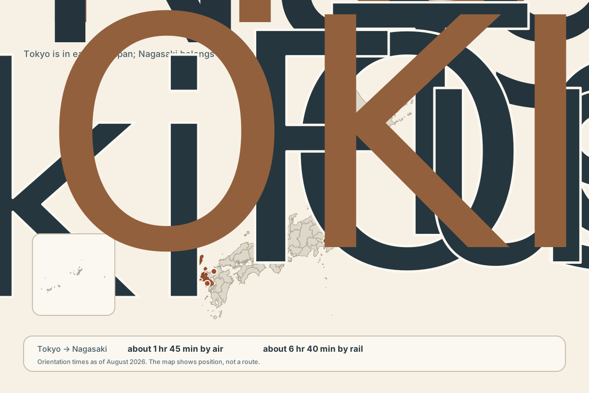
Figure 1. The location of Nagasaki Prefecture within Japan. Boundary data: National Land Numerical Information, Ministry of Land, Infrastructure, Transport and Tourism, 2025; processed by Voyafield.
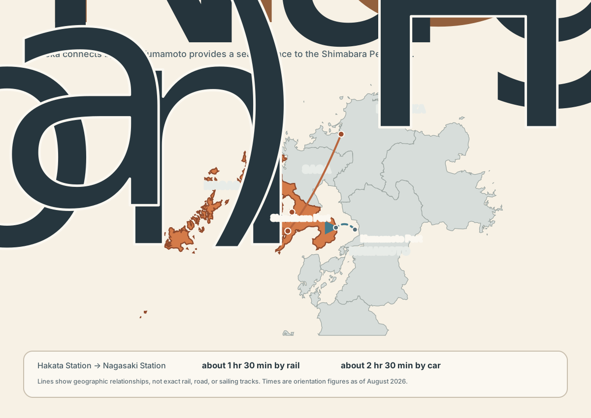
Figure 2. Nagasaki Prefecture within northern Kyushu. The lines are schematic, showing directions of entry rather than exact roads, railways, or sea routes. Boundary data: National Land Numerical Information, Ministry of Land, Infrastructure, Transport and Tourism, 2025; processed by Voyafield.
From Tokyo, the flight from Haneda Airport to Nagasaki Airport takes about 1 hour 45 minutes. Traveling by rail from Tokyo Station to Nagasaki Station takes about 6 hours 40 minutes, including transfers. In most cases, flying is the better way to travel from Tokyo to Nagasaki. These figures are current as of August 2026.
Fukuoka is another major city in Kyushu, although it is not covered in this article. From Hakata Station in Fukuoka to Nagasaki Station, the approximate time is 1 hour 30 minutes by rail or 2 hours 30 minutes by car. This also shows that a visit to Nagasaki Prefecture does not necessarily have to begin at Nagasaki Airport or Nagasaki Station.
Nagasaki Airport is not in Nagasaki city, but in a place called Omura, across the bay. By car, the airport is about 40 minutes from the Nagasaki Station area.
2. Let us divide Nagasaki Prefecture into regions
Nagasaki Prefecture can be divided broadly into seven regions: Nagasaki, Kenou, Kenhoku, Shimabara, Goto, Iki, and Tsushima.
The seven regions are not divided only for convenience. Islands separated by sea, peninsulas facing each other across a bay, and cities formed on limited areas of flat land differ in how people gather, how industry develops, and how transport connects them. Regions with different conditions sit side by side within the same administrative prefecture.
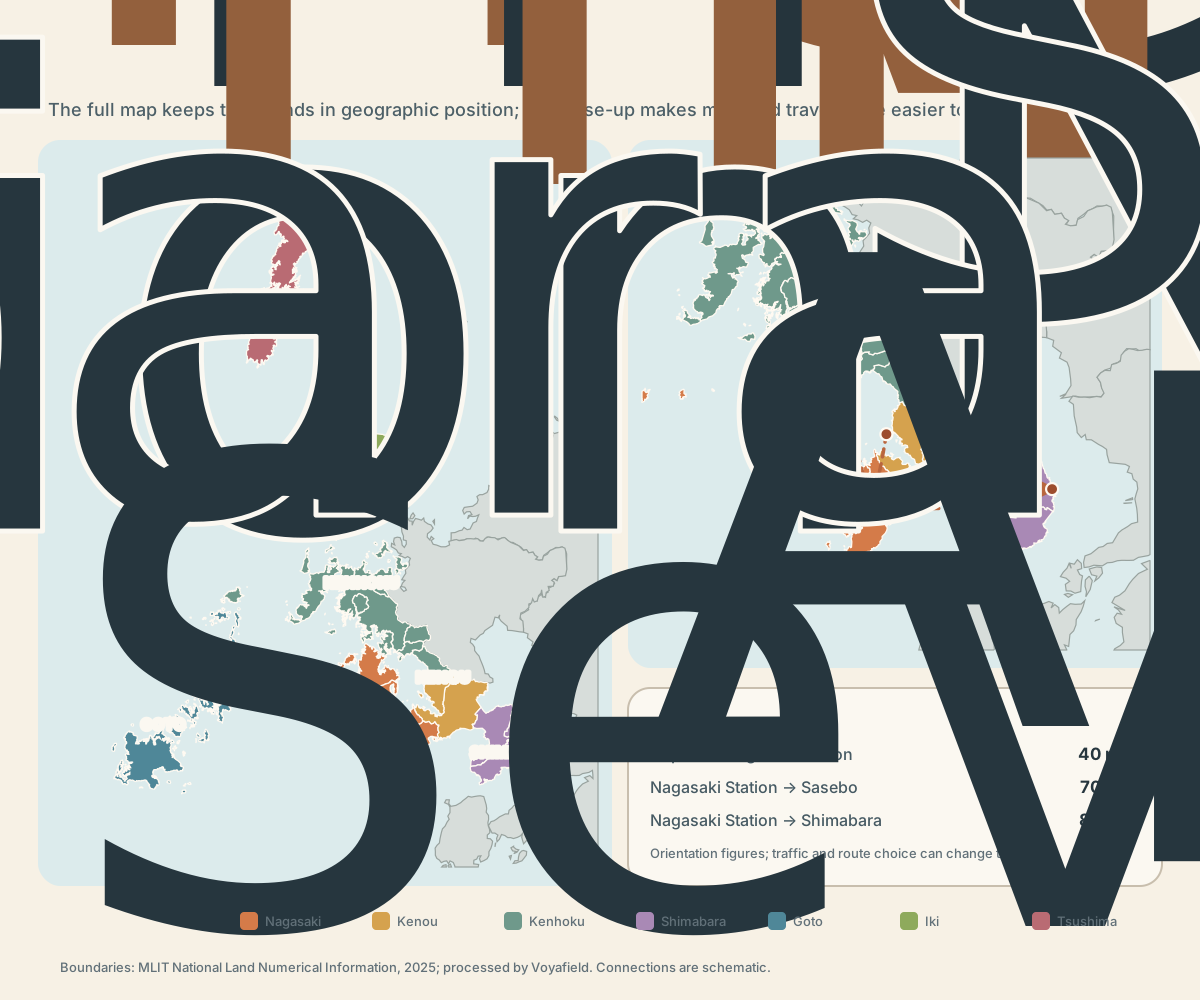
Figure 3. Seven regions within one prefecture. The regional division follows a Nagasaki Prefecture regional guide. Car times are approximate, and the lines are schematic. Boundary data: National Land Numerical Information, Ministry of Land, Infrastructure, Transport and Tourism, 2025; processed by Voyafield.
How large is Nagasaki Prefecture in terms of area?
Nagasaki Prefecture has a land area of approximately 4,131 square kilometers. Comparing it with the administrative areas of well-known cities overseas makes its scale a little easier to see.
| Overseas city administrative area | Approximate area | Comparison with Nagasaki Prefecture |
|---|---|---|
| Greater London | 1,572 km² | Nagasaki Prefecture is about 2.6 times as large |
| Berlin | 891 km² | Nagasaki Prefecture is about 4.6 times as large |
| New York City | 778 km² (land area) | Nagasaki Prefecture is about 5.3 times as large |
| Seoul | 605 km² | Nagasaki Prefecture is about 6.8 times as large |
Administrative systems differ by country, so these are not areas at the same level of government. This is a simple comparison intended to give a sense of Nagasaki Prefecture's size.
However, Nagasaki Prefecture's land does not form a single continuous area. Because there is sea between its islands and peninsulas, area alone does not convey the sense of distance involved in traveling within the prefecture.
3. Four regions on the mainland side
Nagasaki region—Nagasaki city and its surroundings
The urban area spreads outward, and it would be fair to say that this is where the movement of people and commercial activity are greatest. As of July 1, 2026, Nagasaki city's estimated population was about 380,000, the largest of any municipality in the prefecture. About 31% of the prefecture's roughly 1.22 million residents lived in Nagasaki city. Together with Sasebo's roughly 220,000 residents, the two cities accounted for about 49%. Nearly half of the prefecture's population is concentrated in these two cities.
The main places can be visited by combining trams, buses, and walking.
Kenhoku—the north, including Sasebo and Hirado: a journey linking ports, islands, and ceramics
Kenhoku contains places with different characters, including Sasebo, Hirado, Matsuura, Hasami, and Kawatana. Sasebo's character as a port city, the sea of the Kujukushima islands, Hirado's history of exchange, and the ceramics of Hasami and Mikawachi can all be said to have qualities distinct from Nagasaki city.
Kenou—Omura and Isahaya as junctions for travel within the prefecture
Kenou is notable less for the number of sights than for the presence of Nagasaki Airport, Shin-Omura Station, and Isahaya Station. It would be fair to call it a transport hub.
Shimabara—volcanoes, hot springs, spring water, and farmland close together
The Shimabara Peninsula is a region of volcanoes, the hot springs of Unzen and Obama, the spring water of Shimabara city, and other natural features.
The main places can also be reached by public transport. A car is convenient if you want to cross between several hot-spring areas and places known for spring water, while a ferry provides another route in from Kumamoto. It is worth considering Kumamoto as another point of entry.
4. Do not group Goto, Iki, and Tsushima together under the single term “remote islands”
Goto, Iki, and Tsushima are islands in the same prefecture, but their locations, points of entry, and internal scale are different. Beyond these major islands, a national count in 2023 recorded 1,479 islands in Nagasaki Prefecture, including uninhabited ones. Nagasaki has more islands than any other prefecture in Japan.
Goto—decide where in the archipelago to base yourself
Goto is not a single island, but an archipelago. From Nagasaki Port to Fukue Port, the shortest jetfoil crossing is 1 hour 25 minutes, while the ferry takes about 3 hours 10 minutes. Kamigoto and Ojika use different routes from Nagasaki Port, Sasebo Port, and elsewhere. You need to decide first which island to stay on and which port or airport to enter through.
Iki—easier to enter from Fukuoka than from Nagasaki city
Iki lies between mainland Kyushu and Tsushima. From Hakata Port, the jetfoil takes about 65 to 70 minutes to Gonoura or Ashibe port. There are also flights from Nagasaki Airport. If you are entering from Fukuoka, going to Iki without passing through Nagasaki city is often the simpler choice.
Tsushima—long from north to south, with more than one point of entry
Tsushima is in the north of Nagasaki Prefecture and faces the Korean Peninsula. Flights from Fukuoka Airport to Tsushima Yamaneko Airport and boats from Hakata Port to Izuhara Port are the main points of entry; the jetfoil takes about 2 hours 15 minutes. There are also flights from Nagasaki Airport. The island is long from north to south, and the itinerary changes according to how far you travel after arrival.
Sea and air services change with the weather and season. The times here are approximate figures as of August 22, 2026.
Before serving as transport for sightseeing, these routes are infrastructure for residents' daily lives. A study of ferry routes serving remote islands in Nagasaki and Kagoshima shows that timetables directly affect access to high schools, medical facilities, and supermarkets.
5. Population distribution shows how transport and services gather
As of July 2026, Nagasaki Prefecture's estimated population was about 1.22 million. Nagasaki city had about 380,000 residents and Sasebo about 220,000; the two cities alone accounted for about 49% of the prefecture. Add Isahaya and Omura, and the four cities accounted for about 68%.
Tsushima, Iki, and Goto cities each have populations in the twenty- or thirty-thousands. It is important to remember, however, that these are municipal figures, not the populations of the island regions as a whole.
Cities with larger populations tend to gather more choices in accommodation, food, and transport. In less populated regions, departures and opening hours may leave little room for adjustment. These figures should not be used to rank regions, but as a way to consider where an early reservation may be needed.
6. Choose transport by “how far you extend the trip,” not by distance
In Nagasaki Prefecture, the distance between two points does not determine the transport on its own. The decision changes according to whether you stay in one city, cross a peninsula, or travel to an island.
| Range of the trip | Main transport | Point to consider |
|---|---|---|
| Mainly within Nagasaki city | Tram, bus, and walking | Easy to arrange without a car, but consider the strain of the slopes separately |
| Nagasaki city and Sasebo | Rail or car | Rail works for the two cities alone; a car is better for stops between them |
| Sasebo, Hirado, and the ceramic-producing areas | A car is convenient | If using public transport, check the timetable before deciding the order in which you want to visit places |
| Around the Shimabara Peninsula | A car is convenient | Public transport is also an option for one place; if crossing the peninsula, set aside the travel time first |
| Goto | Boat or flight, plus transport on the islands | Decide which island will be the base before choosing how to arrive |
| Iki | Boat from Fukuoka, or flight from Nagasaki Airport | It may be more natural not to go through Nagasaki city |
| Tsushima | Flight from Fukuoka or Nagasaki, or boat from Fukuoka | The island is long from north to south; allow for travel after arrival |
A car is not a universal answer. Reaching an island still requires a boat or plane, and public transport can be easier to use within Nagasaki city. Rather than deciding only whether to rent a car, it is better to decide which parts of the trip to use it for.
7. Do not try to cover everything—choose “this trip's Nagasaki” to suit your conditions
If this is your first visit to Nagasaki and the stay is short, concentrating on Nagasaki city is a reasonable choice. It is not a shortcoming that you did not see the whole prefecture. You can instead think of it as a trip that lets you understand one region without strain.
Even with more days, adding one region that matches your interests will usually be easier to arrange than connecting several regions thinly.
| Interest or condition | Region that is easier to choose | How to think about the itinerary |
|---|---|---|
| First visit, 2–3 days, no car | Nagasaki city and surroundings | Do not add too many trips outside the city; leave room for travel that includes the slopes |
| Ports, islands, and modern history | Sasebo and Hirado | If you go as far as Hirado, give Kenhoku at least one day |
| Volcanoes, hot springs, and spring water | Shimabara Peninsula | Compare a stay on the peninsula with simply making a round trip from Nagasaki city |
| Island geography and life | One of Goto, Iki, or Tsushima | Do not group all three together; choose one by its point of entry and transport within the islands |
| Combined with Fukuoka | Iki, Tsushima, or Nagasaki city | Give priority to the actual route from Hakata Station or Hakata Port, rather than the prefectural boundary |
| Prefer not to drive | An urban base such as Nagasaki or Sasebo | Limit outlying stops and check timetables first |
Nagasaki's geography asks “which Nagasaki will you go to?” before it asks “what will you see?” Once you understand the differences within the prefecture, and separate the region for this visit from those saved for your next visit, a complicated geography becomes a set of choices.
References
- Hiroshi Machida, Yoko Ota, Toshio Kawana, Hiroshi Moriwaki, and Shinji Nagaoka, eds., Nihon no Chikei 7: Kyushu and the Nansei Islands. University of Tokyo Press, 2001. ISBN 978-4-13-064717-5.
- Naoki Kimura, supervising editor; Nagasaki University School of Global Humanities and Social Sciences, ed., Daigakuteki Nagasaki Guide: Kodawari no Arukikata. Showado, 2018. ISBN 978-4-8122-1713-9.
- Hideki Nozawa, Ryohei Domae, and Akira Tezuka, eds., Nihon no Chishi 10: Kyushu and Okinawa. Asakura Publishing, 2012. ISBN 978-4-254-16770-2.
Public and official sources
- Nagasaki Prefecture, guide to the seven regions (“Nagaoshi”): https://nagaoshi.pref.nagasaki.jp/
- Nagasaki Prefecture, “Overview of Nagasaki Prefecture”: https://www.pref.nagasaki.jp/pages/page-11972.html
- Greater London Authority, “London in Figures”: https://apps.london.gov.uk/state-of-london/report/london-in-figures
- State of Berlin, “State of Berlin – Investor Presentation”: https://www.berlin.de/sen/finanzen/vermoegen/geld-und-kreditgeschaeft/state-of-berlin-investor-presentation.pdf
- U.S. Census Bureau, “QuickFacts: New York City”: https://www.census.gov/quickfacts/fact/table/newyorkcitynewyork/POP060220
- Seoul Metropolitan Government, “Evolution of the Administrative Districts”: https://english.seoul.go.kr/city-hall/history-of-administration/2-evolution-of-the-administrative-districts/
- Nagasaki Prefecture, estimated population as of July 1, 2026: https://www.pref.nagasaki.jp/
- Nagasaki Prefecture, “Nagasaki's Islands” (source for 1,479 islands and 51 inhabited islands): https://www.pref.nagasaki.jp/
- Geospatial Information Authority of Japan, “Number of Islands in Japan” (2023 recount): https://www.gsi.go.jp/kihonjohochousa/islands_index.html
- Nagasaki Prefecture Tourism Association, access guide: https://www.discover-nagasaki.com/en/featured-topics/nc-access
- JR Kyushu, Nagasaki–Hakata access by the Nishi-Kyushu Shinkansen: https://www.jrkyushu.co.jp/railway/netyoyaku/route/nagasaki/
- Nagasaki Airport, access guide: https://www.nagasaki-airport.jp/access/guide/
- Kyushu Shosen, Goto routes and crossing times: https://kyusho.co.jp/routes
- Kyushu Yusen, Iki and Tsushima routes: https://www.kyu-you.co.jp/
- Kumamoto Ferry, Shimabara–Kumamoto route: https://www.kumamotoferry.co.jp/timefare/